Off to Jasper! Up to this point we were on roads that we’ve visited before but were glad to be back because they are some of our favorites. This would be our chance to reach the northern reach of the Ice Fields Parkway for a couple of days in Jasper National Park.
We loaded the bikes while swatting the swarming mosquitoes and were on the road by 9:00 enjoying the morning’s cool temperature. The rain had moved off and the weather app (Carrot) promised good riding conditions. We were following the Trans Canadian Highway east towards Lake Louise. Immediately we started climbing to the 4,000 feet at Roger’s Pass wedged between two 9,000 foot glaciated peaks named Avalanche Mountain and Mount Shifton.
The Trans-Canada Highway stretches across all ten Canadian provinces connecting the Pacific and Atlantic coasts. According to Wikipedia, it’s approximately 4,860 miles long. Hmm, now that would be a good trip. This part of the T-Can as it is sometimes known was a lightly traveled mountain route and fun on the motorcycles.
This map might be a little better because you can zoom in.
It was a planned 300 mile day and the bikes were chewing up the miles on the nice two lane road. As we approached the famous city of Lake Louise we started climbing again to over 5,000 feet in the Canadian Rockies and we reached the border with Alberta. Immediately we started seeing signs requiring us to purchase permits to travel through the park but were glad the fees were being waved for the summer. Even for Americans!
We didn’t stop at Lake Louise but it’s on my list for a future visit. Instead we turned left on Highway 93, the icefields Parkway. This road actually has a website: https://icefieldsparkway.com/ how cool is that? Here is an excerpt from the website:
A journey through Banff National Park and Jasper National Park. Linking Lake Louise with Jasper is one of the most beautiful journeys on the planet – the icefields Parkway, Alberta’s Highway 93.
The icefields Parkway is rated as one of the top drives in the world by Condé Nast Traveller.
It’s open year-round and offers a 232 km stretch of double-lane highway with soaring rocky mountain peaks, icefields, a variety of wildlife, birds, and vast sweeping valleys. Prepare to be amazed during the best road trip of your life.
Funny, we were so amazed we forgot to take any pictures! We did stop at a waterfall along the way for a short hike and some pics. 
Large glacier peaked mountains surrounded us the whole way.

It was a fun ride through the icefields, at the peak the road was just under 7,000 feet in elevation. We stopped for lunch and gas at the Crossing Resort which was roughly halfway to our hotel. Wow, a nice place… why didn’t we stay there? I bookmarked it for next time.
After lunch the clouds were forming and as we got closer to Jasper there were a few drips on our windscreens.I had our destination for two nights, the Miette Mountain Cabins, programmed into my GPS, and when we passed through the city of Jasper in the increasing rain, it said we had 27 miles to go.
I didn’t expect to be so far from town. Deby asked about a restaurant. Did it have one? I couldn’t remember. I usually try to book accommodations that either has a restaurant or there is one nearby. Once we are off the bikes and out of our boots neither of us feel like getting back on looking for food.

well, the cabins were nice enough but food? Nope. Breakfast? Nope. We were on our own. I asked at the front desk and the nearest restaurant was about 10 miles away. Nope, we weren’t going to do that in the rain. Time to take inventory… look here, a couple cans of beer in my pannier, ha, at least we could have pork chops! Ok, we got that covered. Deby went to the hotel office to see what they had and came back with two tubs of noodles. Ok, we had a small kitchen and a hot water pot so we were good to go. True road food.

In the hotel lobby I asked about a breakfast location and I picked up a tourist brochure with things to do in the area. The breakfast recommendation was the restaurant at the Miette Hot Springs. We were glad the rain let up in the morning and we took off in cool weather to run the 10 miles up to the Hot Springs. It turned out to be an excellent twisting mountain road with spectacular viewpoints. Here is a picture of the hot springs from the Travel Alberta website.

Wow, we walked around and were amazed by the scenery. We weren’t prepared to jump in but added it to our list for next time. The restaurant served an excellent breakfast and we noticed they had lodging in small cabins. Dang, why didn’t we just ride a few more miles to stay here??? We’ll stay there next time for sure.
I have to pause here to talk about the devastating wildfire that happened here only a year prior in July 2024. The following is from various internet accounts of the fire:
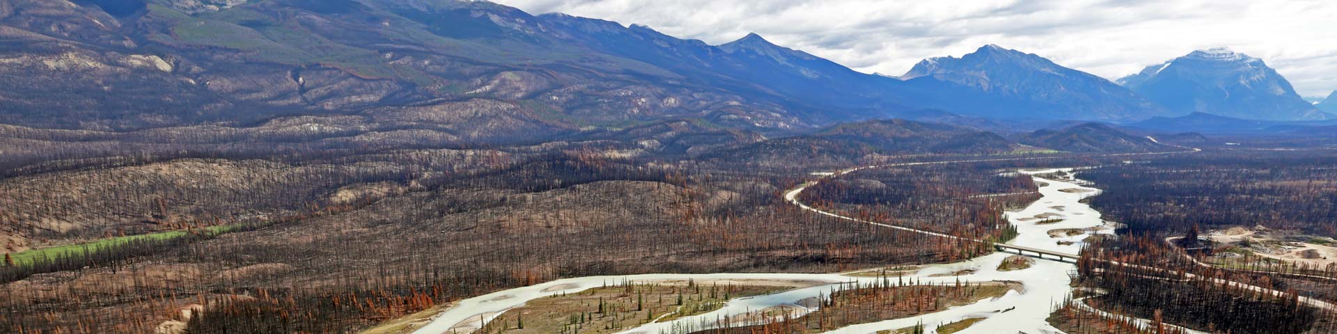
A devastating and historic wildfire, known as the Jasper Wildfire Complex, occurred in Jasper National Park and the town of Jasper, Alberta, in late July 2024. The fires were started by lightning and spread rapidly due to extreme drought conditions and strong winds, creating a “pyrocumulonimbus cloud” and its own weather system.
The fire was the largest in Jasper National Park in over a century, burning an estimated 32,722 hectares (over 80,000 acres). It forced the evacuation of approximately 25,000 people, including both residents and visitors, and caused significant damage to the town and surrounding areas.
Damage to Structures: The fire destroyed a significant portion of the town. Preliminary assessments indicated that about a third of all structures in the town of Jasper, 358 out of 1,113, were destroyed. The damage was concentrated on the west side of town.
Evidence of this fire was everywhere as you would expect. It’s amazing to me that about a third of the structures in town were destroyed. We rode through town and there was still the burned out hulk of a large gas station and many empty lots. On the edge of town were rows and rows of FEMA style mobile housing units. There was a lot of new construction everywhere but clearly this is going to be a long term proposition getting the city back to normal.
We stopped at a wayside and tried to get pictures to capture some of the devastation.


A somber reminder of nature’s power. More information about the fire is here on the Parks.Canada website.
We planned a day off here to explore the area. The hotel brochure recommend a boat tour of Maligne Lake. According to the description online, “Maligne Lake Road in Jasper is one of Canada’s most scenic roads. It takes you past amazing sights like Maligne Canyon and Medicine Lake and ends at Maligne Lake, leaving any visitor more than satisfied.”
Ok, sounded like our kind of road and as a matter of fact we were indeed more than satisfied. The road was an in-and-out 30 mile run with the last few miles gravel road. The bikes ate up the curves as we checked out the surrounding mountains. We wanted to stop and do the hike into Maligne Canyon but the trail was closed due to fire damage.
Maligne Lake was another amazing stop. It’s a glacial lake known for turquoise colored water. We took a boat tour to Spirit Island which is supposed to be one of the most photographed spots in Canada. Wait, how do you pronounce Maligne? We learned the g is silent similar to how the g is silent in through. So it’s pronounced like Ma-leen. The tour guide made it sound more like Mo-leen. Maybe that’s the Canadian way to do it. Ok, moving on….
I will admit, it’s a beautiful lake.

Glaciers on the surrounding mountains.
Here is the tour boat. 
This is Spirit Island. Technically it looked more like a peninsula and much smaller than I expected but does make for a good picture.

Altogether it was well worth the side trip to Maligne Lake.
The next “not to miss stop” in the tourist brochure was the Jasper Skytram just outside the town of Jasper. The Jasper Skytram is touted as being “the longest and highest guided aerial tramway in Canada, offering stunning panoramic views of Jasper National Park. Canada’s Highest and Longest Guided Aerial Tramway has Unmatched 360° Views.”
Here is a picture from their website. https://www.skytramjasper.com/

You can see the town of Jasper on the right side of the picture. Here is a picture I took that shows some of the blackened trees. 
Still, an amazing place. We talked with the tram operator about the fire. She was working the tram when it started and had to be evacuated from the mountain. It was interesting that her attitude was that this was just part of nature and in a way it was good for the forest. Ok then. I asked about the campground on the far right side of the picture and she pointed out that the campground has 5,000 camp spots which is equal to the population of the city. Wow. 
We had a bite to eat at the not very crowded restaurant with a most spectacular view. 
I know I say ‘wow’ a lot, but that picture is a big ‘wow.’
As you can see from the pictures the weather was threatening rain all day long but so far we were dry. On the way back to the cabin I had to pull over to take this amazing picture.
So, this would be our most northern stop of our trip and as we left the next day we felt like we were on our way home. We did have a few unexpected surprises on the route home. We started the ride home by re-riding the Ice Fields Parkway north to south. There is a favorite saying Deby and I often use that I can’t remember where it came from. “You don’t truly know a road until you’ve ridden it in both directions.” We’ve found it to be really true.
Somehow while messing around online at the cabin I found a website called GuideAlong. GuideAlong is an app that is a location based audio tour. The idea is that you load the app and the tour you want to take and as you are driving, or riding in our case the tour guide on the app tells you what you are seeing along the road based on your GPS location. There was a guide for the Ice Fields Parkway I loaded it onto my phone and synced it up with my helmet. I tried to get it to work in Deby’s helmet without success so we headed south with a tour guide talking in my ears.
The tour guide was highly entertaining in my helmet. It might be a computerized voice but it sounded like the cartoon bear at the Brown Bear car wash chain. If you’re not familiar it’s hard to explain, but wait, I can’t believe I found it online. Ha, here it is.
So we’re riding down the Ice Field Parkway and I have this bear voice in my head telling me an extended history of the area and fun facts. Deby can’t hear the bear but she can hear me so I’m busy listening and relaying the summary of the tour to Deby in her helmet. May-beee that is distracted riding? We didn’t crash so I’m calling it good.
Without the bear we wouldn’t have known to stop at the Athabasca Falls. It’s a short drive off the parkway and well worth the stop. 
The falls drop down into a narrow canyon that you can explore. 
I kind passerby took our picture in on of the walkways. 
After that there is a short hike to Lake Athabasca with more amazing views of the turquoise colored lake. 
This was one of the most crowded stops in the park. It soon became readily apparent that Deby and I as white, english speaking anglo saxons were in a very small minority. Part of that is that Alberta is a very diverse provence with a large South and Southeast Asian population. We heard many languages spoken and I tried my best to sort them out. Perhaps international tourists are opting to visit Canada’s National Parks this year. Without exception everyone was friendly and just out enjoying what nature has to offer. It really is a small world and it’s fun to be part of it.

Too soon we were back on the Parkway riding south with the bear back in my head. It was highly entertaining all the way to Banff where the bear bid farewell.
We decided to make a loop into Calgary the capital city of Alberta for a quick overnight before setting course for the dirt section of highway 40 south to highway 3.
The weather was getting better and it was perfect when we hit the dirt section. I found a helmet cam picture of the easy gravel roadbed. 
Once on highway 3 we finally turned west, here is a picture of Deby and the mighty Honda near Crowsnest Pass. 
We stopped for lunch in the small town of Crowsnest Pass and another biker from Colorado parked next to us. He was riding a very loaded down Yamaha Tenere. He joined us for lunch and we found out he was on his way to the Calgary airport where he was shipping his bike to Paris France for an extended European motorcycle tour. It was super interesting hearing about his plans. Unfortunately he wasn’t posting about his trip on any social media platforms or it would have been fun to follow his travels. We wish him the best.
By this point in our trip we were making hotel reservations on the fly each day depending on the weather and how far we thought we would ride for the day. We had an idea of a rough route home taking us east through Canada and then dropping into the US about midway through the state of Washington. So, somewhat randomly I booked us for a night at the St. Eugene Golf, Resort, Casino near Cranbrook, BC. They had availability, it was more or less on our way, had a restaurant, and it wasn’t too expensive. I usually avoid anything with a casino but the pictures looked like a historic building so we booked it.
I didn’t know what an experience it would be….
From their website:
The St. Eugene Mission in British Columbia was an Indian Residential School that operated from 1912 to 1970, forcing Indigenous children from their families to be assimilated into Western culture. The site, near Cranbrook, was run by the Catholic Church and was the first of its kind in the Canadian West. After its closure, the building was repurposed into a successful tourism venture by the Ktunaxa Nation, transforming a symbol of pain into a space for cultural revival, education, and economic development.
The schools were part of a policy to assimilate Indigenous people into the non-Native population. This included attempts to extinguish Native language, spirituality and culture. The Truth & Reconciliation Commission has since called the government policy and actions at this time “cultural genocide.”
It’s buried in the hotel website, but a good history is here: https://www.steugene.ca/discover/history-heritage/residential-school-history/
Our room was actually in the restored old school building that was rumored to be haunted.

I took pictures some photos on the walls. 

A short walk from the hotel is the location of 182 graves just recently discovered in 2021. It’s unclear who exactly is buried there but community work had begun to identify weather the graves are of some ot the children forced to attend the school. You can read more about that HERE in this CBC report. 
We walked over and took this picture but there were signs asking people to respect the property and stay outside the fence.
I went to visit the interpretive center on the ground floor and learned much more about this history of the building and the schools that were used to round up indigenous children.
The hotel and casino is owned and operated by the 4 Ktunaxa Nation bands (including the ‘Aquam, ‘Akisqnuk, Yaq̓it ʔa·knuqⱡi’it (Tobacco Plains), Yaqan Nukiy (Lower Kootenay) Bands and Shuswap Indian Band. we were super impressed by the way they presented the history of the place with an emphasis on healing and moving forward.
I think this plaque on the wall about sums it up.

I have to admit the whole property was beautifully landscaped with three excellent restaurants and the once abandoned school house was nicely restored. In the interpretive center I learned it only recently opened just as COVID hit and then had to close down. They said they are just now getting going again. I would highly recommend this place as a great place to stay.
Are we home yet?
Playing it by ear we decided to return to the city of Kaslo on the shores of Kootenay Lake. We’ve been there a few times before but never really had time to check it out so we booked two nights in, what else, a small cabin within walking distance of town.

It was a cozy A frame at the Sunny Bluffs Chalets a 5 unit place run by a really nice couple who migrated from Europe 10 years ago. We took a day off from our vacation to hike around town, visit some restaurants and we spent a long afternoon at the most idyllic city park. 
Now within a two day ride from home we started getting anxious for our own beds so we headed south and crossed into the U.S. and the impossibly small border crossing along the Columbia River near Boundary, WA. I think we arrived at lunch time because nobody was around and the gate was down. We waited for about 15 minutes, not sure what to do before someone came out and waved us over to his booth. Again, it was an easy border crossing with cursory questions about where we had been and if we had any drugs.
We rode south to Kettle Falls where the thermometer passed the 90 degree mark. Whew. We were glad to catch highway 20 west to climb over Sherman Pass enjoying the cooler air at 5,000 feet. We knew the cool wouldn’t last as we headed downhill where we had to pass through the always hot city of Omak. We hit the highest temperature of the trip, 101 degrees, arrg. Once again I was glad to get out of there and cool off riding up four thousand foot Loup Loup pass just outside of our destination of Winthrop, WA.
We’ve been to Winthrop many, many many times and feel like we know all the hotels and campgrounds in the area. I was surprised that there was availability at one of our favorite places, the Methow River Lodge and Cabins. Yup, that’s right, another cabin! Maybe I should have called this the Canada cabin tour? Here was our cabin for the night. 
These are really nice cabins and I recommend them highly. It was a short walk into the main part of the western themed town where we had our last dinner on the road. I took a picture of this sign above the cabin door. 
Do people really have to be reminded not to peek in windows? Who knows, maybe…
Almost home
One of my favorite rides home from Winthrop is on the North Cascades Scenic Highway. This highway is rightly categorized as the best motorcycle road in Washington state. And, and what to you know, there is a download on GuideAlong for this road. Ok, I was determined to get it to work with Deby’s helmet speakers and I finally did. We had a most entertaining ride home with “the bear” talking to us the whole way, filling our heads with fun facts and pointing out the sights and places to hike along the way.
All in all we rode about 3,000 miles. Both bikes did great. Deby is super happy about her new Honda NX500 and I think it will be a keeper. As of this writing her BMW F750GS has been in the shop for 5 weeks and counting. Will it ever be the same? What should we do with it?
Here is a zoomable map of our whole trip.
It’s good to be home but only for a short time. In September we’re flying to Germany for a motorcycle tour with a couple of friends and then off to Italy for a couple of weeks of riding. I’m not bringing my laptop but hopefully I can post a full account when we get back.
You can always watch our progress by clicking on the “Live Map” tab at the top of our home page.
Thanks for reading and all the comments, it’s fantastic to hear from old travel friends from Bolivia (Marco, keep riding that Honda, we miss you bro.) to England ( Mark and Claire, great to hear from you. Same to Paul and Francoise). Of course, thanks to the tourmaster himself GPS Kevin for saying hello, let’s ride soon. Thanks to Sal, our longest time follower and good friend from Milwaukee and to the notorious Jesse James in AZ (you still there?). Hello to Willie, I’m waiting to hear about your trip with the Garys. Thanks to the incomparable Seattle motorcycle historian and legend Tom Samuelsen for saying hi. So long as I’m going on here I have to mention my old band mates Bill and Jeff, frequent travel buddies Kim and Kris, neighbors Barb and Llamara and fellow adventurer Scott P.
More to come.
Donn and Deby
Thanks for sharing your adventures with us Donn.
I’m looking forward to the Fall Blogs as well.
Thanks Sal, glad to entertain you during morning coffee. The next blog posts will be about your homeland…
What an absolutely incredible trip! That is some beautiful scenery!